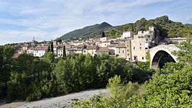
Nyons
Appearance
Nyons
Niòns (Occitan) | |
|---|---|
Subprefecture and commune | |
 A general view of Nyons | |
| Coordinates: 44°21′37″N 5°08′23″E / 44.3603°N 5.1397°E | |
| Country | France |
| Region | Auvergne-Rhône-Alpes |
| Department | Drôme |
| Arrondissement | Nyons |
| Canton | Nyons et Baronnies |
| Intercommunality | CC des Baronnies en Drôme provençale |
| Government | |
| • Mayor (2020–2026) | Pierre Combes[1] |
Area 1 | 23.45 km2 (9.05 sq mi) |
| Population (2022)[2] | 6,794 |
| • Density | 290/km2 (750/sq mi) |
| Demonym | Nyonsais |
| Time zone | UTC+01:00 (CET) |
| • Summer (DST) | UTC+02:00 (CEST) |
| INSEE/Postal code | 26220 /26110 |
| Elevation | 234–940 m (768–3,084 ft) (avg. 270 m or 890 ft) |
| Website | www.nyons.com |
| 1 French Land Register data, which excludes lakes, ponds, glaciers > 1 km2 (0.386 sq mi or 247 acres) and river estuaries. | |
Nyons (French pronunciation: [njɔ̃s]; Occitan: Niòns) is a subprefecture of the Drôme department in the Auvergne-Rhône-Alpes region in Southeastern France. In 2021, the commune[clarification needed] had a population of 6,771.
Nyons is a sub-prefecture of the department.[citation needed] Its olives have PDO status.[3]
Geography
[edit]Nyons is located close to the boundary of the Vaucluse department.
The commune is situated around 70 km south of Valence, the prefecture of the Drôme department, 40 km south-east of Montélimar, 45 km north-east of Orange, and 70 km north of Avignon, the prefecture of the Vaucluse department.

Population
[edit]
|
| |||||||||||||||||||||||||||||||||||||||||||||||||||||||||||||||||||||||||||||||||||||||||||||||||||||||||||||||||||||
| Source: EHESS[4] and INSEE (1968-2020)[5] | ||||||||||||||||||||||||||||||||||||||||||||||||||||||||||||||||||||||||||||||||||||||||||||||||||||||||||||||||||||||
Sights
[edit]Twin cities
[edit]Nyons is twinned with:[citation needed]
 Manciano, Tuscany, Italy
 Mechernich, North Rhine-Westphalia, Germany
 Nyon, Vaud, Switzerland
 Nules, Castellón, Spain
 Borca, Neamț, Romania
Notable people
[edit]- Philis de La Charce (1645-1703), French war hero in the Nine Years' War.
- Joseph Roumanille (1818-1891), Provençal poet, he lived in Nyons from 1843 to 1844.
- Clair Tisseur (1827-1896), French architect
- Adrien Bertrand (1888-1917), Novelist awarded the Prix Goncourt.
- René Barjavel (1911-1985), Science fiction author.
See also
[edit]References
[edit]- ^ "Répertoire national des élus: les maires" (in French). data.gouv.fr, Plateforme ouverte des données publiques françaises. 13 September 2022.
- ^ (in French). The National Institute of Statistics and Economic Studies. 19 December 2024 https://www.insee.fr/fr/statistiques/8288323?geo=COM-26220.
{{cite web}}: Missing or empty|title=(help) - ^ Olives noires de Nyons - Profile, EU PDO/PGI Database (Accessed 27 July 2010)
- ^ Des villages de Cassini aux communes d'aujourd'hui: Commune data sheet Nyons, EHESS (in French).
- ^ Population en historique depuis 1968, INSEE
External links
[edit]Wikimedia Commons has media related to Nyons.


